By Elias Marat | Creative Commons | TheMindUnleashed.com
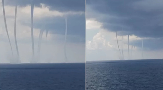
As the Gulf Coast braces itself for the disastrous possibility that it will get thrashed by two hurricanes this week, incredible video footage has emerged of six humongous, spinning waterspouts off of Louisiana’s coast in the Gulf of Mexico.
In a shocking video captured by Frank LeDay, the waterspouts – which are tornado-style phenomena that form over water – can be seen off the coast southwest of Galliano, Louisiana, creating a jaw-dropping and awe-inspiring scene.
While the video and stills from the image seem like something not of this world, they’re just the latest surreal images to emerge from the truly unusual year 2020.
In a separate video filmed up close in Leevilee, Louisiana, another massive waterspout can be seen churning through the ocean.
Ed Piotrowski, a meteorologist at WPDE, took to Facebook to describe the phenomenon as the “most picturesque spouts I’ve ever seen. It almost looks like War of the Worlds out there!”
The naturally-occurring spectacles come as residents of the Gulf Coast and coastal Louisiana have begun evacuating ahead of Hurricane Marco and Tropical Storm Laura, which authorities fear could absolutely pummel the state this coming week.
Several parishes have ordered mandatory evacuations of residents, while residents in Orleans Parish – the home of New Orleans – were urged to voluntarily evacuate by Sunday evening, reports Weather Channel.
Marco strengthened from a tropical storm to a Category 1 hurricane on Sunday and is expected to make landfall on Louisiana’s coast as soon as Monday.
Tropical Storm Laura is expected to strengthen to a hurricane by the time it lands on the U.S. mainland through or near the Louisiana coast late Wednesday or early Thursday.
According to National Weather Service meteorologist Benjamin Schott, Laura could become a Category 3 storm on its path to the state, threatening severe flooding as far as 30 miles inland.
The National Hurricane Center of the National Oceanic and Atmospheric Administration (NOAA) has warned that “life-threatening storm surge and hurricane-force winds” are expected to hit parts of the Gulf Coast on Monday.
Schott told CNN that two back-to-back hurricanes striking the same region in such a short span of time are a shock that hasn’t been seen in modern times.
“The unprecedented kind of thing here is that it’s the same state within 48 hours of each other,” Schott said.
“In modern meteorological history … there’s never been anything like this before where you could have possibly two hurricanes hitting within miles of each other over a 48 hour period.”
On Saturday, Louisiana Gov. John Bel Edwards requested that the federal government declare an emergency due to the potential damage the two hurricanes can cause.
“This is unlike anything we have seen, with two hurricanes expected to impact our state nearly back to back,” Edwards said. “This may mean that people will have to shelter in place for more than 72 hours and that there may not be time to do things like restoring lost power between the two storms.’
On Sunday, President Trump approved the emergency declaration from Louisiana, which orders federal assistance to aid local authorities in responding to the potentially disastrous conditions resulting from Hurricane Marco and Tropical Storm Laura.
In exactly three days from now, here's what the HWRF model says a Hurricane Laura could look like as it's approaching the Gulf Coast.
I'll say it very simply: Laura poses a potentially catastrophic threat to the Texas and Louisiana coast.
Watch this storm very closely. pic.twitter.com/o7RKwH0mpl
— Eric Holthaus (@EricHolthaus) August 24, 2020


